Typhoon Francisco has intensified while moving west northwestward over the Philippine Sea on Monday, June 22, 2026, prompting the Philippine Atmospheric, Geophysical and Astronomical Services Administration (Pagasa) to warn of strong winds, rough seas, and possible heavy rainfall in parts of the country.
Current Location and Strength
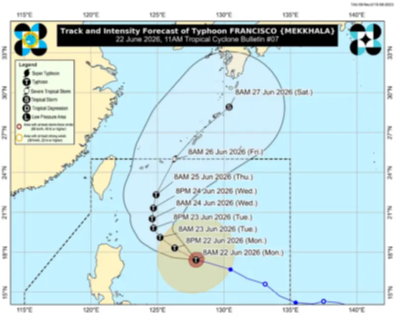
In its 11 a.m. tropical cyclone bulletin, Pagasa reported that Francisco was located 620 kilometers east of Tuguegarao City, Cagayan. The typhoon packs maximum sustained winds of 155 kilometers per hour (kph) near the center and gusts of up to 190 kph. It is moving west northwestward at 15 kph.
Wind Signal No. 1 Hoisted
Tropical Cyclone Wind Signal No. 1 remains hoisted over Batanes and the northeastern portion of Cagayan, particularly Gonzaga and Santa Ana, including the eastern part of the Babuyan Islands. Pagasa said minimal to minor impacts from strong winds are possible in these areas, with winds of 39 to 61 kph expected within 36 hours.

Southwest Monsoon and Outer Circulation Effects
The southwest monsoon, enhanced by Francisco's outer circulation, is expected to bring strong to gale-force gusts over several areas, including most of the Visayas, parts of Luzon, and Mindanao. The state weather bureau also warned mariners against venturing into rough seas along the eastern seaboards of Babuyan Islands and mainland Cagayan, where wave heights may reach up to 3.5 meters. Moderate to rough sea conditions are likewise expected in several coastal areas of Northern Luzon, Bicol, Eastern Visayas, and eastern Mindanao.
Forecast Track and Exit
Pagasa said Francisco is forecast to continue moving generally northwestward until Tuesday before turning north northeastward toward the Ryukyu Islands in southern Japan. The typhoon is expected to remain far from the Philippine landmass and may exit the Philippine Area of Responsibility by Friday, June 26. However, Pagasa noted that a slight westward shift in the forecast track remains possible and stressed that heavy rainfall and strong winds may still be experienced outside the forecast confidence cone.
Potential Intensification
Francisco is expected to intensify further and may reach its peak strength by Tuesday. Pagasa added that the possibility of the cyclone reaching super typhoon category has not been ruled out.
Precautionary Measures
Residents in affected areas were advised to monitor the latest weather bulletins, inspect their homes for possible repairs, clear drainage systems, and take necessary precautions against flooding and strong winds.