
Tropical Storm Higos is expected to enter the Philippine Area of Responsibility (PAR) on Friday, June 26, 2026, and will be given the local name Gardo, according to the weather bureau.
Higos Location and Movement
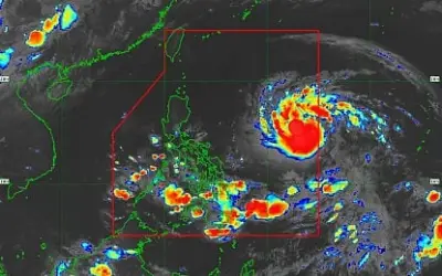
As of 10:00 a.m. on Wednesday, June 24, Tropical Storm Higos was located 2,120 km east of Central Luzon. It is moving west-northwest at a speed of 20 kilometers per hour (kph).
The storm has maximum sustained winds of 65 kph near the center, with gusts reaching up to 80 kph.

No Direct Impact Expected
According to the Philippine Atmospheric, Geophysical and Astronomical Services Administration (Pagasa), Higos is expected to remain far from land and is not anticipated to directly affect weather conditions or sea conditions.
It is forecast to remain a tropical storm, but Pagasa did not rule out the possibility that it could intensify into a severe tropical storm.
Typhoon Francisco Update
Meanwhile, Typhoon Francisco is gradually weakening. It has maximum sustained winds of 140 kph near the center and gusts of up to 170 kph.
Typhoon Francisco was last spotted 295 km east-northeast of Basco, Batanes, moving northward at 10 kph.
Pagasa reported that Francisco is bringing heavy rain across Batanes and Cagayan, while Zambales, Bataan, Occidental Mindoro, Palawan, and Antique are also experiencing heavy rain due to the southwest monsoon.
A gale warning remains in effect for the northern and eastern seaboards of Northern Luzon, the bureau added.