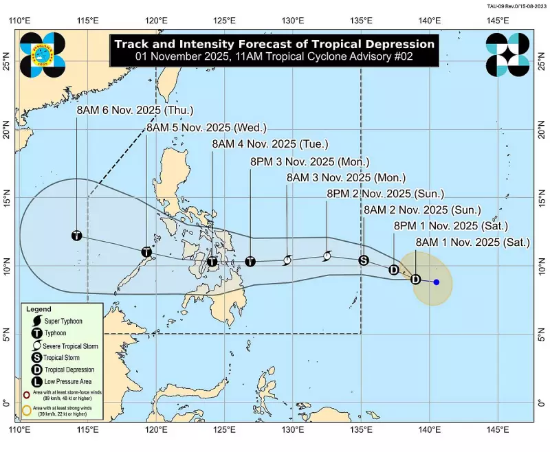
ILOILO CITY - A new weather disturbance is brewing in the Philippine Area of Responsibility, with Tropical Storm Tino expected to make its presence felt in Central Visayas and Western Visayas regions in the coming days.
The Philippine Atmospheric, Geophysical and Astronomical Services Administration (PAGASA) has issued an early warning as the storm continues to develop over the Pacific Ocean. Weather experts are closely monitoring Tino's trajectory, which shows a high probability of affecting Cebu and neighboring provinces.
Expected Impact and Timeline
According to the latest weather bulletin, Tropical Storm Tino is projected to approach the Visayas region by early next week. Residents in coastal and low-lying areas should prepare for:

- Heavy to intense rainfall starting Monday
- Strong winds reaching 45-60 km/h
- Possible flooding in flood-prone areas
- Rough sea conditions for maritime travel
Preparations Underway
Local government units across Western Visayas have begun precautionary measures. Disaster risk reduction management councils are on alert, with emergency response teams placed on standby.
"We advise the public, especially those in vulnerable areas, to monitor updates regularly and prepare emergency kits," stated a PAGASA representative during a press briefing.
Areas Most at Risk
The weather bureau has identified several areas that could experience the storm's direct impact:
- Cebu Province and surrounding islands
- Negros Occidental and Negros Oriental
- Iloilo Province and Guimaras
- Capiz and Antique provinces
Fisherfolk and those with small seacraft are advised to avoid venturing into the eastern seaboards of Visayas and Mindanao as sea conditions are expected to become hazardous.
The public is encouraged to stay tuned to official weather updates from PAGASA and follow instructions from local authorities as Tropical Storm Tino develops.