
The state weather bureau reported on Thursday, May 7, 2026, that Tropical Storm Hagupit (international name) could enter the Philippine Area of Responsibility (PAR) over the weekend. Once inside, it will be locally named “Caloy.”
Storm Track and Intensity
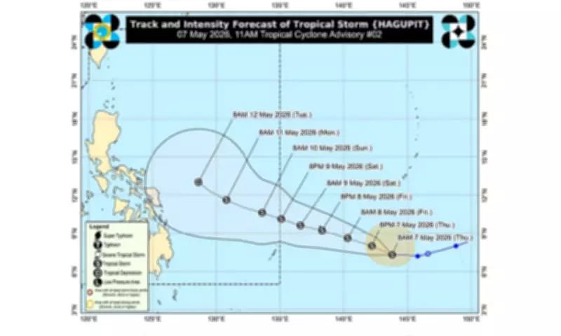
As of 4 a.m., the Philippine Atmospheric, Geophysical and Astronomical Services Administration (Pagasa) estimated the center of Hagupit at 1,995 kilometers east of northeastern Mindanao. The storm is moving westward at 20 kilometers per hour, with maximum sustained winds of 65 kph near the center and gusts of up to 80 kph.
Pagasa stated that Hagupit will continue moving westward for the next six hours, then shift to a west-northwestward direction for the rest of the forecast period. It may enter PAR between Saturday evening and Sunday morning.

The storm is expected to intensify into a high-end tropical storm within the next 48 hours. However, it may weaken afterward and be downgraded to a tropical depression by Tuesday while over the Philippine Sea.
Minimal Direct Impact Expected
The weather bureau noted that Hagupit is unlikely to directly affect weather and sea conditions in the country over the next three days.
Low Pressure Area Brings Rains
Meanwhile, Pagasa monitored a low pressure area (LPA) estimated at 120 kilometers southeast of Hinatuan, Surigao del Sur, as of 3 a.m. The LPA is unlikely to develop into a tropical depression.
However, the LPA is expected to bring cloudy skies with scattered rains and thunderstorms over Central Visayas, Eastern Visayas, Negros Island Region, Caraga, Northern Mindanao, Davao Region, and Zamboanga Peninsula.
Metro Manila and the rest of the country will experience partly cloudy to cloudy skies with isolated rain showers or thunderstorms due to the easterlies.
Flood and Landslide Warnings
Pagasa warned of possible flash floods or landslides due to moderate to heavy rains caused by the LPA, as well as severe thunderstorms triggered by the easterlies.