A groundbreaking 45-year analysis of tropical cyclone data has uncovered critical patterns in how storms behave as they approach and strike the Philippines, one of the world's most vulnerable regions to such weather systems.
Key Patterns: North vs. South
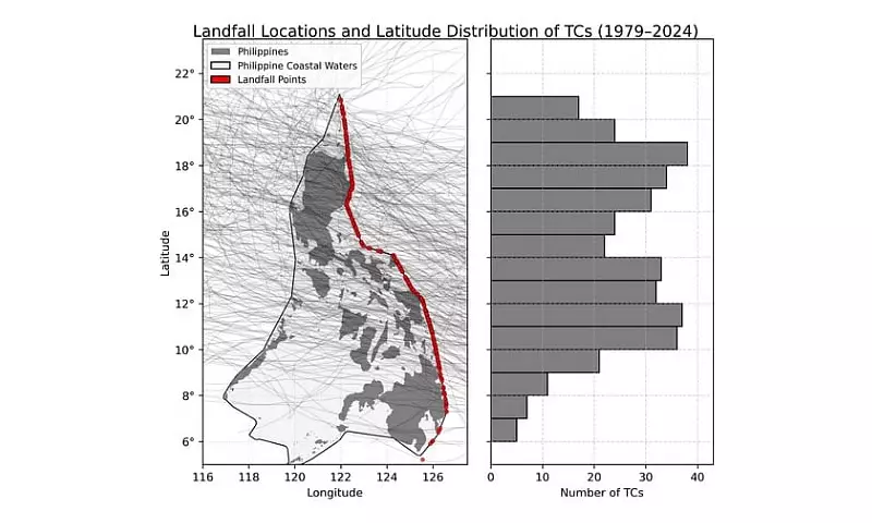
Researchers Drs. Bernard Alan Racoma and Gerry Bagtasa from the University of the Philippines – Diliman College of Science’s Institute of Environmental Science and Meteorology (UPD-CS IESM) studied 372 landfalling tropical cyclones from 1979 to 2024. Their work reveals a stark geographical divide in storm characteristics.
"Storms that hit the northern part of the country tend to be stronger but slower moving. Southern storms tend to be faster and accelerate more rapidly," explained Dr. Racoma. This divergence has major implications for the types of hazards communities face.

Fast-moving storms in the Visayas and Mindanao give residents very little time to prepare and evacuate. In contrast, the stronger, slower-moving cyclones that frequently impact Luzon increase the risk of prolonged, catastrophic events like severe flooding and landslides due to extended heavy rainfall.
Brief Coastal Presence Despite Long PAR Stays
The study also highlighted a crucial finding for emergency response. While tropical cyclones often linger within the Philippine Area of Responsibility (PAR) for several days, their direct impact along the nation's coastlines is surprisingly brief.
On average, a storm's direct presence over Philippine coastal waters lasts only about 21 hours before it moves inland or away. Dr. Racoma offered two explanations for this rapid transit.
"In terms of geometry, the Philippines is somewhat slender: the country is longer north-south, compared to east-west. Since TCs usually move from east to west, they tend to cross this shorter path faster," he said. "Another possible explanation is the loss of the fuel source—the warm ocean. TCs draw their energy from the sea, and they typically don't like staying over land."
Urgent Call for Proactive Preparedness
The meteorologists stress that understanding both the timing and intensity of storms is fundamental to reducing disaster risk. They warn communities against complacency, especially given the phenomenon of rapid intensification.
"Rapid intensification occurs very fast—typically within 24 hours. We don't yet fully understand it; even weak storms can intensify quickly," Dr. Racoma noted. "We should avoid waiting for a storm to intensify before preparing. Half of TCs that form or enter the PAR make landfall, and usually rapid intensification occurs within this region."
The researchers recommend that the public and local governments treat all developing storms with seriousness and begin monitoring as soon as a cyclone enters or forms within the PAR.
The study, titled "Characteristics and Near-Landfall Behavior of Tropical Cyclones Affecting the Philippines (1979–2024)," was published in the journal Tropical Cyclone Research and Review. The research received support from the UPD Office of the Vice Chancellor for Research and Development and the Department of Science and Technology – Philippine Council for Industry, Energy, and Emerging Technology Research and Development.