Tropical Storm Basyang Weakens to Low-Pressure Area Over Sulu Sea
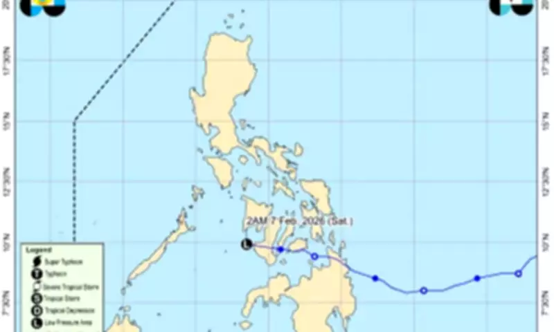
The Philippine Atmospheric, Geophysical and Astronomical Services Administration (PAGASA) reported in its early morning bulletin on Saturday that Tropical Storm Basyang, known internationally as Penha, has weakened into a low-pressure area (LPA). This development occurred as the storm moved west-northwestward over the Sulu Sea, with unfavorable environmental conditions contributing to its dissipation.
Current Location and Forecast Movement
According to PAGASA, Basyang weakened into an LPA at approximately 2 a.m. on Saturday. It was last tracked about 105 kilometers southeast of Cuyo, Palawan. The remnant low is expected to continue moving generally west-northwestward over the Sulu Sea and may cross northern Palawan. However, forecasters warn that it could dissipate further as it encounters increasingly unfavorable conditions during its trajectory.
Heavy Rainfall Impacts Across Multiple Regions
The LPA, combined with the prevailing shear line, is anticipated to bring significant rainfall to various parts of the country. PAGASA has issued specific forecasts for heavy precipitation:

- Rainfall of 50 to 100 millimeters is expected over Palawan, Oriental Mindoro, Negros Occidental, Antique, Iloilo, and Guimaras due to the LPA.
- Heavy rainfall associated with the shear line is forecast over Quezon and Camarines Norte.
Forecasters caution that rainfall amounts may be higher in mountainous and elevated areas. The impacts could be exacerbated by significant antecedent rainfall, potentially leading to flooding or landslides in vulnerable locations.
Strong Winds and Hazardous Sea Conditions
Aside from heavy rains, the surge of the northeast monsoon will bring strong to gale-force gusts, particularly affecting coastal and upland areas exposed to winds. These conditions are expected over:
- Most of Luzon
- Western Visayas
- Most of the Negros Island Region (NIR)
- Zamboanga del Norte
PAGASA has issued warnings for hazardous sea conditions, advising mariners to seek shelter or safe harbor until winds and waves subside. Specific forecasts include:
- Rough seas of up to 4 meters over the remaining seaboards of the Babuyan Islands and the seaboards of Ilocos Norte.
- Waves of up to 3 meters may affect the seaboards of Ilocos Sur, Cagayan, Isabela, Aurora, northern Quezon, as well as the northern and eastern seaboards of the Polillo Islands.
- Moderate seas of up to 2.5 meters are forecast over several other seaboards, including those of the Ilocos Region, Camarines Norte, Camarines Sur, Catanduanes, Northern Samar, Albay, Sorsogon, Eastern Samar, Dinagat Islands, Siargao-Bucas Grande Islands, Surigao del Sur, and Davao Oriental.
- Seas of up to 2 meters are expected along the eastern seaboard of Davao Occidental.
Mariners operating small sea crafts, such as motor bancas, are strongly advised not to venture out to sea, especially if vessels are ill-equipped or operated by inexperienced crews.
Regional Weather Forecasts
PAGASA provided detailed weather outlooks for different areas:
- Western Visayas, NIR, and Mimaropa: Cloudy skies with scattered rains and thunderstorms due to the LPA.
- Metro Manila, Calabarzon, Bicol Region, Aurora, Northern Samar, and Eastern Samar: Cloudy skies with scattered rains and isolated thunderstorms caused by the shear line.
- Batanes, Cagayan, Isabela, and Apayao: Cloudy skies with rains due to the northeast monsoon.
- Rest of Luzon: Partly cloudy to cloudy skies with isolated light rains.
- Rest of the country: Partly cloudy to cloudy skies with isolated rain showers or thunderstorms due to localized thunderstorms.
Residents in affected regions are urged to stay updated with the latest weather advisories from PAGASA and take necessary precautions against potential hazards.