
The Philippines braces for a major weather emergency as Typhoon Uwan undergoes rapid intensification over the Philippine Sea, potentially reaching super typhoon strength within the next 24 hours. The Philippine Atmospheric, Geophysical and Astronomical Services Administration (Pagasa) issued this critical update on Saturday, November 8, 2025.
Current Storm Position and Movement
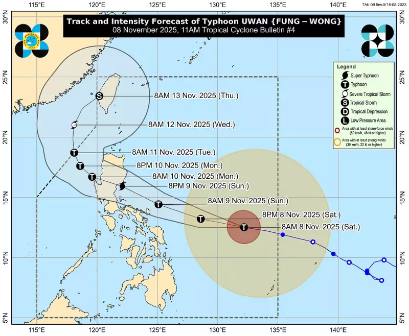
As of 11 a.m. on Saturday, weather monitors located Uwan's eye approximately 680 kilometers east of Borongan City, Eastern Samar. The storm system was also positioned about 760 kilometers east of Catarman, Northern Samar, packing dangerous wind speeds.
The typhoon currently generates maximum sustained winds of 140 km/h near its center, with powerful gusts reaching up to 170 km/h. Uwan maintains a westward movement at 35 km/h, putting multiple regions in its projected path.

Pagasa forecasts the typhoon will shift to a west-northwestward trajectory, potentially passing close to Catanduanes on Sunday morning. Landfall is expected over either the southern portion of Isabela or northern Aurora by Sunday night or early Monday.
Emergency Preparations and Warnings
Weather authorities have raised Tropical Cyclone Wind Signal No. 2 over several vulnerable areas including Catanduanes, Albay, Sorsogon, Ticao Islands, and parts of Camarines Sur and Northern Samar. These regions should prepare for gale-force winds within the next 24 hours that could cause light to moderate damage to structures and agricultural areas.
The less severe Signal No. 1 remains in effect across most of Luzon, including Metro Manila, Northern and Central Visayas, and sections of Mindanao. These areas should anticipate strong winds and intermittent rains within 36 hours.
Pagasa issued a critical warning about life-threatening storm surges exceeding three meters along coastal areas of Luzon, Bicol, Eastern Visayas, and Northern Mindanao within the next 48 hours. Emergency management officials strongly urge residents in low-lying coastal communities to evacuate to higher ground immediately.
Maritime Dangers and Intensity Forecast
A gale warning remains active across the northern and eastern seaboards of Luzon and the eastern seaboard of Visayas. Mariners should expect extremely dangerous sea conditions with waves reaching up to 14 meters. All sea travel is considered risky, particularly for smaller vessels and motorbancas.
Weather specialists predict Uwan will continue strengthening and likely reach peak intensity before making landfall. While the typhoon may weaken slightly while crossing Northern Luzon, it's expected to maintain typhoon strength as it moves toward the West Philippine Sea on Monday.
Disaster response agencies nationwide have been placed on alert status as Uwan approaches Philippine landmass. Residents in affected regions should secure property, ensure mobile devices are fully charged, and monitor official weather advisories regularly for updates.