Typhoon Uwan Gains Strength as it Approaches Philippine Landmass
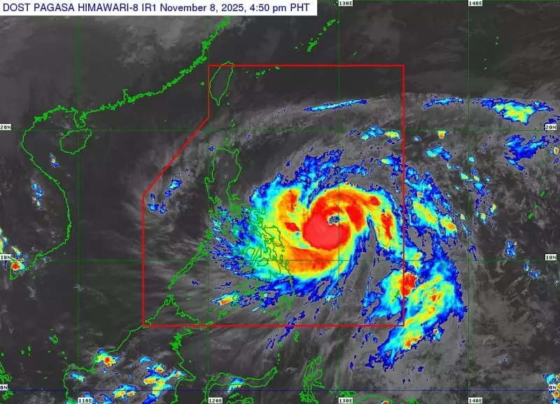
The state weather bureau Pagasa reported that Typhoon Uwan continues to rapidly intensify as it moves closer to the Philippine Sea east of the Bicol Region. According to their 5 p.m. advisory on Saturday, November 8, 2025, the typhoon is showing no signs of weakening as it approaches the country.
Current Location and Movement Patterns
The center of Typhoon Uwan was positioned approximately 575 kilometers east of Catarman, Northern Samar, or alternatively 620 kilometers east of Virac, Catanduanes. The weather system is packing maximum sustained winds of 150 kilometers per hour near the center with gustiness reaching up to 185 km/hour.
Meteorologists are tracking the typhoon's movement pattern, noting it is currently traveling in a west-northwestward direction at 30 km/hour. This trajectory puts multiple regions in Luzon directly in the storm's path.

Impending Landfall and Severe Weather Threats
Pagasa has issued a serious warning regarding life-threatening storm surges with peak heights that could exceed three meters within the next 48 hours. These dangerous conditions are expected to affect low-lying or exposed coastal areas across several regions.
The areas most at risk include parts of Northern Luzon, Central Luzon, Bicol, Northern Samar, Eastern Samar, and portions of Mindanao such as Dinagat and Siargao Islands.
Weather experts predict that Uwan will make landfall over the northern portion of Aurora either on Sunday evening, November 9, or early Monday, November 10. Following landfall, the typhoon will cross the mountainous terrain of Northern Luzon and is forecast to emerge over the West Philippine Sea by Monday.
Potential Super Typhoon Development
In a concerning development, Pagasa added that Uwan may intensify into a super typhoon by Saturday night or Sunday due to highly favorable atmospheric conditions. This potential escalation increases the threat level for communities in the typhoon's path.
Tropical Cyclone Wind Signals Activated
The weather bureau has hoisted Tropical Cyclone Wind Signals over numerous areas across the country:
TCWS No. 3 has been raised in:
- Luzon: Catanduanes, eastern Camarines Sur, eastern Albay, and northeastern Sorsogon
- Visayas: Northeastern portion of Northern Samar
Signal No. 2 covers extensive areas including:
- Luzon: Eastern Cagayan, Isabela, Quirino, Nueva Vizcaya, Aurora, Nueva Ecija, Bulacan, Metro Manila, Rizal, Laguna, Quezon, and multiple other provinces
- Visayas: Rest of Northern Samar, northern Samar, and northern Eastern Samar
Signal No. 1 is in effect for:
- Luzon: Batanes, rest of Cagayan including Babuyan Islands, Apayao, Abra, and numerous other provinces across Northern and Central Luzon
- Visayas: Rest of Samar, rest of Eastern Samar, Biliran, Leyte, Southern Leyte, Bohol, and northern and central portions of Cebu including surrounding islands
- Mindanao: Dinagat Islands, Surigao del Norte, northern Agusan del Norte, and northern Surigao del Sur
Residents in affected areas are urged to monitor official updates from Pagasa and follow evacuation orders from local authorities. Emergency preparedness kits should be ready, and coastal communities should take immediate precautions against potential storm surges.